Learning from the Blue Water Bridge
But the part I found fascinating and very applicable today was how they determined where Sarnia's new Bridge should go. I wondered as I read the document whether it could give us any insight. After all we are talking about spending up to $6 billion on a new crossing on both sides of the river on a new bridge, plaza and infrastructure. We have engineers looking at straight bridges, twin bridges, S-bridges and diagonal bridges.
Just like my BLOG ["A Waste Of Three Years"] on the Report on the "Michigan-Ontario Railroad Border Crossing Infrastructure" which was completed in December 1991, I wondered why no one seems to have mentioned this history. I am disappointed that MDOT has been sitting on a document that could have given us some guidance. I wonder what else is sitting on the dusty shelves of the bureaucracies in Michigan and Ontario that could have saved us years of work and millions of taxpayer dollars. Perhaps the Michigan representatives could ask that question too in their hearings.
You be the judge after reading this excerpt about what we should do in our region. Doesn't it sound eerrily familiar to what we have been going through:
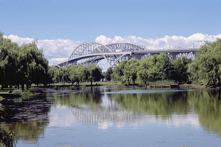
- "At 6,535 feet long, construction of the Blue Water Bridge spanning the St. Clair River between Port Huron, United States and Point Edward, Canada posed its own challenges during the 1930s. Nearly sixty years later, construction of a second bridge just south of the historic Blue Water Bridge offers a unique chance to compare past and present stories behind these two monumental structures...
Increasing traffic on the Blue Water Bridge prompted the Ontario Ministry of Transportation and Communications and the Michigan Department of Transportation to find a location for a second bridge. They assembled an international team of engineers, transportation planners and environmental planners to direct the study. Much thought went into the location of the second bridge. The team selected three locations to examine: one adjacent to the existing bridge, another to the south, between Marysville and Sarnia and yet another even further south between Marine City and Sombra, Canada. The study team wanted to know if a new bridge at any of these three locations would divert enough traffic from the Blue Water Bridge to significantly extend its life. The study also looked at a tunnel option.
The tunnel did not fare well in the analysis. Building a tunnel would cost three to four times more than a bridge. Likewise, new bridges at the two southern locations would cost two times more than a bridge next to the existing. New access roads and toll/customs facilities drove up the price of these options. More importantly, the existing highway systems in both countries led to the Blue Water Bridge site and a new bridge to the south would not divert enough traffic to benefit the old one.
The study also established a maximum capacity for the Blue Water Bridge. When the traffic volumes reached 1,500 vehicles per hour, then construction of a second bridge should be planned and implemented. It also made several short-term suggestions for improvements including re-striping the pavement markings on the bridge to provide for a truck-climbing lane and expanding the Michigan bridge plaza.
After holding public meetings and studying several alternative locations for a second bridge, the team members recommended that a second bridge be constructed just to the south of the existing bridge...
A new bridge to the south of the existing one would require less displacement of property and homes than one to the north. The southern location would also accommodate the expansion of the bridge plazas on both the U.S. and Canadian sides of the bridge...
Both countries completed major freeways leading to the bridge. I-69 in Michigan and Highway 402 in Canada provided an attractive low-traffic alternative to the Detroit-Windsor route. Ironically the original Blue Water Bridge Commission planned for the bridge to serve the Montreal to Chicago International route, but the descendent of this route did not become a freeway reality until the 1990s."
In other words, a twinned bridge at the existing location made the most sense from a cost and plaza perspective and disrupted the fewest number of people. The road system in the region already was geared around the existing bridge. Moreover, they just did not build it but waited until traffic justified its construction.
An interesting lesson to be learned from all of this no doubt.
posted by JoeBlog at 12:10 p.m.
![]()


<< Home